![]()
![]()
EOMAP software processor
EOMAP develops software processors for the operational retrieval of water quality parameters and land-water masks using multispectral satellite sensors. The product generation is performed by complete physics based retrieval algorithms, which ensures inter-operational standardized products even from different spatial and spectral resolved satellite sensors. In the first project year EOMAP improved the fully coupled atmospheric and in-water retrieval algorithms. We created first river turbidity maps and land-water masks using MODIS 250m, 500m and 1km resolution images of the Mekong delta and analyzed spatial high resolved scenes with 3-30m resolution (Landsat ETM, IKONOS, QuickBird) for the suspended matter retrieval in 3 to 30m spatial resolution. The operational generation of water quality parameters requires known inherent optical properties of the optical active water constituents. Therefore we performed successfully the first river measurement campaign in collaboration with SiWRR (Ho Chi Min City) and DLR Oberpfaffenhofen. The datasets were used to calculate the first set of SIOP’s specific for the Basac river of the delta and essentially improved the ground truth independent product generation.
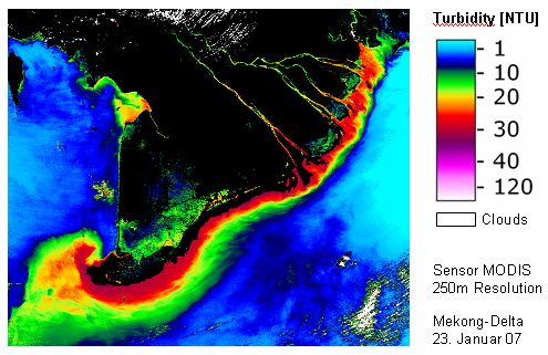
Figure 1 - Spatial distribution of turbidity and suspended matter in the Mekong delta