Fontsize: [-] Text [+]

Hydrology and Hydraulics

Combined fluvial and pluvial flood hazard analysis for Can Tho city

Can Tho city is the largest city and the economic heart of the Mekong Delta, Vietnam. Due to its economic importance and envisaged development goals the city has witnessed a large growth in both population size and extend over the last two decades. Although city development plans exist, the city is growing uncontrolled in many areas, among which some are quite flood prone.

Spatial variability and uncertainty of floodplain sedimentation monitoring in the Mekong Delta

The floodplain sedimentation samples reported in June 2012 ("Large scale monitoring of floodplain sedimentation") were further evaluated in order to quantify the inherent uncertainty of the sampling procedure and to depict the spatial variability of the floodplain sedimentation. The sample layout of three traps per sampling location enabled an uncertainty analysis of the point samples, which was performed for the first time for sediment samples. The analysis revealed that the sampling uncertainty can be considerably high, and increases with higher deposition masses.

Large scale modelling of sediment dynamics

This study focus on the suspended sediment dynamics and sediment-nutrient deposition in the whole Mekong Delta (MD), by apply quasi-2D hydrodynamic model combined with a measurement campaign on sediment-nutrient deposition in floodplains in Vietnam.

GPS reflectometry for water level monitoring

To test the possibility of using GNSS-Reflectometry as a water level monitoring instrument, a first measurement campaign has been made between the 25th February and 7th Mars 2012 in Vietnam at Can Tho city. The typical building height along the coasts of the Mekong Delta in this area doesn’t exceed 40m so that one challenge will be to separate the direct signal from the reflected one.


Sediment dynamics in the Mekong Basin – model setup and calibration

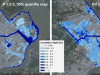
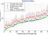
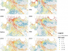
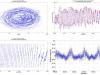
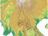
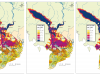
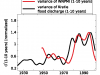
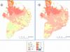
The hydrological model SWIM (Krysanova et al., 1998) was set up to assess the discharge and sediment dynamics of the  Mekong  basin down to the gauging station in Kratie/Cambodia. The model is driven by ERA-INTERIM reanalysis data (Dee et al., 2011) and APHRODITE (Yatagai et al., 2009) precipitation data. The model calibration and validation is, at a first step, based on the discharge and sediment data provided by the Mekong River Commission (MRC) and a multi-objective calibration aiming at optimal model performance in the time and frequency domain. With respect to the heterogeneous (temporal and spatial) data availability, different parameter regions are defined (see Fig.  1).

GPS buoys for water level monitoring in large rivers

Monitoring of river stages is one of the basic observations required for understanding catchment hydrology and hydraulic systems. There are numerous measurement techniques available for this purpose, but in case of large rivers technical as well as financial problems often restrict the use of traditional techniques, e.g. pressure probes or float gauges. We explored the potential of Global Navigation Satellite System (GNSS) based water level measurements for stage monitoring by developing small and easy to handle buoys equipped with high-precision geodetic GNSS receivers.

Large scale monitoring of floodplain sedimentation

Floodplain sedimentation plays an important role for the agro-ecosystem in the Mekong Delta. In phase 1 of WISDOM the sediment dynamics and processes were studies in detail on a selected part of the floodplain. In this second phase, the spatial variability of floodplain sediment deposition is both monitored and simulated. For this purpose an extensive monitoring scheme was implemented for the flood season 2011. It consists of approximately 450 sediment traps distributed over the main inundation areas of the Mekong Delta (Plain of Reeds and Long Xuyen Quadrangle).

Floodplain sediment dynamics

Suspended sediment dynamics are the primary source for a sustainable agro-ecosystem in the Mekong Delta by providing nutrient input for the subsequent farming season. However, little is known about the dynamics of suspended sediment in the floodplains of the Delta. In particular, quantitative data about the inundation processes in the floodplains are non-existent. In order to investigate the suspended sediment transport in both channels and floodplains in the Plain of Reeds in the Mekong Delta, an extensive monitoring network was established in a representative study area of 165 km2.

Future flood hazard in the Mekong Delta

Flood hazard analysis is an indispensable input for flood risk assessment.  An essential part is the determination of probabilities of occurrence of floods of different magnitudes. However, the underlying assumption of stationarity does not hold for most of the observed discharge time series in general, and in particular not for future climate conditions. This is of particular importance for low lying coastal areas and estuaries like the Mekong Delta, which is one of the most vulnerable areas for climate change impacts world-wide.

Linking floods in the Mekong Basin to large scale climate phenomena

The Mekong River in Southeast Asia thanks its regular annual flood to the southwest monsoon. At longer time scales, the monsoon is a spatially and temporally variable circulation, with different annual to millennial variation for different regions. Within WISDOM, the Indian and the Western Pacific components of the monsoon were analyzed and related to the inter-annual flood variability of the Mekong River.

Floodplain hydrology and hydraulics

This short report shows some results of the floodplain monitoring in the Dong Thap province of the Mekong Delta. Figure 1 compares water level time series for two stations, representative for main river (T1) and secondary channel in floodplains (H11), respectively, for the years 2008 and 2009. It can be seen that the hydrograph characteristics in the channels and the floodplains are generally identical, except of the tidal influence. The tidal influence is dampened in the floodplains due to lower inundation depths and the low momentum of the huge inundation area in the floodplains.

Multi-objective automatic hydraulic model calibration

Automatic calibration of hydrodynamic models is – compared to other disciplines like e.g. hydrology – still underdeveloped. This has mainly two reasons: the lack of appropriate data and the large computational demand in terms of CPU-time. Both aspects are aggravated in large-scale applications.

Hydrodynamic modeling of the Mekong Delta

A 1D hydrodynamic model of the Mekong Delta developed at SIWRR was further improved by collecting more data on dike lines and elevations and an improved representation of the floodplains in the one-dimensional model domain. With the new data it was calibrated against the record flood in 2000 and additionally validated by simulating the flood in 2001. Both calibration and validation runs show a very good agreement with the recorded discharges.

Hydrology of the Mekong Basin – non-stationary time series analysis

At a first step in time series analysis efforts to identify average trends in annual maximum discharge and 90-day annual minimum discharge in the gauges Vientiane, Thakhek, Pakse and Kratie were undertaken. In a further step the use of non-linear techniques for assessment of variability along time in the dataset, considered a fundamental aspect to characterize hydrological change in the catchment.

Monitoring of floodplain processes

Part I – the instrumentation scheme


The different inundation survey systems were deployed to the field as illustrated in Figure 1.


Part I – the instrumentation scheme


The different inundation survey systems were deployed to the field as illustrated in Figure 1.


Hydrology of the Mekong Basin

First statistical analysis of discharge data sets longer than 80 years from major stations along the Mekong river showed a decreasing trend both in the magnitude of flood and low flow events, i.e. the mean annual peak discharges are decreasing, whereas the low flow periods tend to yield higher discharges. These linear trends are shown for the annual maximum discharges in Figure 1.

Hydraulics in the Mekong Delta – Investigation area Tam Nong

The investigation area in Tam Nong has been equipped with a large number of sensors in order to monitor the inundation and sediment transport dynamics. The whole instrumentation scheme encompasses:


Copyright © 2018 German Aerospace Center (DLR). All rights reserved.