Fontsize: [-] Text [+]

Remote Sensing Results

Analysis of MODIS Land Surface Temperature in the Mekong Basin

Land surface temperature (LST) can be used as indicator for climate variability and change and is measured by various satellite sensors. For this research MODIS (Moderate Resolution Imaging Spectroradiometer) data were used to analyze spatial and temporal patterns in the Mekong Basin (MB).

Wetland loss in the Ha Tien Plain

The Ha Tien Plain, located in the north-western part of the Mekong Delta, was once considered to be the last remaining extensive wetland area of seasonally inundated grassland in the Mekong Delta, supporting a high diversity in flora and a rich avifauna. Since the mid-1990s this valuable wetland ecosystem is threatened by the conversion into agriculture, aquaculture and forest plantations.

Soil Moisture Dynamics in the Lower Mekong Basin

Time series of backscatter data measured by the C-band scatterometers aboard European Remote Sensing Satellites (ERS‑1&2) and the first Meteorological Operation (Metop-A) satellite were used for mapping soil moisture dynamics in the Lower Mekong Basin (LMB). Information on soil moisture variability in the LMB is valuable for many applications such as in hydrological modeling, weather forecasting, flood early warning, drought monitoring, agriculture, and climate studies.

Geostatistical Processes for Flood Reporting Established

Different functions have been developed that perform different types of raster statistical analysis. In particular these functions generate histograms of pixels of a input image file that intersect either vector geometries or raster masks. The processes have been established as Web processing Services (WPS).


Vietnam – Can Tho Province – Impervious Surface Cover, 2009

The map illustrates the results of remotely sensed estimations of impervious surface cover which can be defined as any surface cover that prevents the infiltration of water into the soil and is primarily associated with transportation (streets, parking lots, driveways, sidewalks etc.), building rooftops, and compacted soil.

Processor to determin landcover changes developed

These tools are meant to support change detection analysis for e.g. landcover classifications from remote sensing data. They are based on the comparison of a pair of discrete raster images as e.g. coded landcover classifications from different years. They provide statistical and map information allowing the quantitative, qualitative and spatial evaluation and interpretation of changes that occured between the two input dates.


WamaPro - Watermask Processor for automatic watermask calculation from radar satellite imagery

WamaPro combines developed processing steps for the calculation of watermasks to a fully automatic processing chain. Before every single step had to be performed individually with partially high load in user interaction. The single processes have been transformed to Web Processing Services (WPS) and connected to processing a chain with the new developed WPS Orchestration. The WPS orchestration combines web data (WFS, WCS) and processing services (WPS) by connecting output variables to next process’s input variables.


Water quality parameters derived from remote sensing data

For the monitoring of water constituents in the site of investigation "Can Tho" two kinds of satellite data were used. Figure 1 shows SPOT4 satellite data (Spotimage, 2008-03-12, 03:15:57) and a map showing Total Suspended Matter (TSM) -corresponding "Turbidity"- based on the SPOT4 image. Turbidity [NTU] correlates to Particule Matter PM [mg/l]. The legend on the right side of the map describes the scaling of NTU. Start with light blue color for low Total Suspended Matter values going up to 60 NTU colored in pink.


Land Cover Classification 2007, from SPOT image – Can Tho Testsite

The title of this map (Fig. 1) is “Land Cover Classification 2007, Can Tho testsite”. It depicts a classification of the land cover of the earth’s surface derived from satellite data, consisting of natural surfaces, such as vegetation and water, as well as artificial surfaces, such as urban areas.

Land Use Classification 2007, from Quickbird satellite image – Tam Nong Testsite

The title of this map (Fig. 1) is “Land Use Classification 2007, Tam Nong testsite”. Besides the pixel-based approaches one of which the automated processor is still focussing on there are object-oriented classification approaches which are known to achieve very good results for classifying very high resolution data because of detail of information contained in the image.

Population density in districts, 2004

The title of this map is “Vietnam – Mekong Delta –Population density in districts, 2004”.


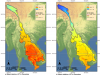
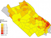
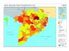
Population density in the Mekong Delta, 2004

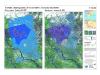
The title of this map is “Vietnam – Mekong Delta –Population density, 2004”.


It depicts the distribution of population in the Mekong Delta. The legend on the right side of the map describes important map attributes, such as the class names, scaling factor, two quicklook images of the data source and additional map information. As the data source of this map, LandScan 2004 Global Population database of the Oak Ridge National Laboratory, was employed.


Land Cover Classification I, 2001

The title of this map is “Vietnam – Mekong Delta – Land Cover Classification I, 2001”.


Land Cover Classification II, 2001

The title of this map is “Vietnam – Mekong Delta – Land Cover Classification II, 2001”.


EOMAP software processor

EOMAP develops software processors for the operational retrieval of water quality parameters and land-water masks using multispectral satellite sensors. The product generation is performed by complete physics based retrieval algorithms, which ensures inter-operational standardized products even from different spatial and spectral resolved satellite sensors.

Seasonal Inundation of the Mekong Delta derived from TerraSAR-X Satellite Data

The title of this map is “Vietnam – Mekong Delta – Plain of reeds – Seasonal inundation”.


Copyright © 2018 German Aerospace Center (DLR). All rights reserved.